



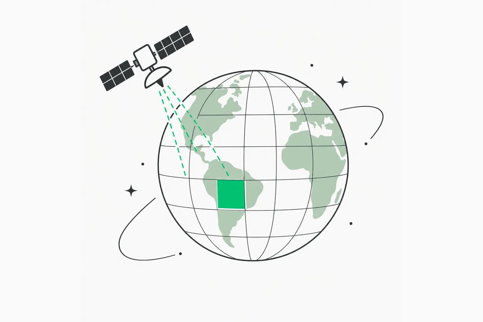
Ai2 has released a map of what the planet looks like to an AI model, and made it free to use. OlmoEarth v1.3, announced October 22, 2026, is a satellite embedding model that turns a year of radar and optical imagery into a 128-number description of every 10-meter pixel on Earth. Ai2 has precomputed those embeddings for the whole globe, shipped a browser tool to explore them without signing in, and says the model weights, pretraining data and code are open. On Ai2's own tests it beats Google's AlphaEarth Foundations and Tessera v2 on 20 of 27 evaluations.
This is the kind of release that is easy to miss and useful to a lot of people: crop mapping, deforestation monitoring, and change detection without a GPU cluster.
TL;DR table
| Question | Answer |
|---|---|
| What is it | An open satellite embedding model plus precomputed global embeddings |
| Inputs | One year of Sentinel-1 radar, Sentinel-2 and Landsat multispectral time series |
| Output | One 128-dimensional vector per 10 m pixel (first 64 dimensions usable alone) |
| Benchmark claim | Top score on 20 of 27 evals (128-d); 18 of 27 (64-d), vs AlphaEarth Foundations and Tessera v2 |
| Open? | Weights, pretraining data and code, under the OlmoEarth Artifact License |
| Access | Embeddings on Source Cooperative; no-login Embeddings Explorer; OlmoEarth Studio for custom runs |
| Coverage | 2023 to 2025 global; 2017 to 2022 select countries; about 150 TB per year |
| Training cost | About $2,720 of rented H100 time for the final Base run |
What is a satellite embedding, in plain terms?
An embedding compresses what a model has learned about a place into a short list of numbers. If two pixels have similar vectors, the model thinks they look and behave alike over the year: two fields growing the same crop, two patches of forest, two mining scars. Ai2 describes the benefit as "compute once, reuse everywhere": instead of training a model per task over raw imagery, which needs GPU access and downloading and storing the satellite data, you train a small classifier on the ready-made vectors and run it locally.
OlmoEarth v1.3 builds the vectors with a vision transformer that reads the time series, an Attention Pooler that collapses it to one vector per patch of land, and a linear layer that reduces it to 128 numbers. The first 64 numbers also work as a smaller embedding.
What did Ai2 release?
Four things, per the announcement:
- OlmoEarth v1.3 Base, the model.
- Precomputed annual global embeddings at 10 m, in 64 and 128 dimensions, on Source Cooperative.
- The OlmoEarth Embeddings Explorer, a browser tool.
- A technical report, plus a new crop-type benchmark called PLANTEUR for tropical farming.
It sits next to the earlier OlmoEarth model family Ai2 launched in November 2025, which was used through OlmoEarth Studio: fine-tune a model per task, then run it over imagery to make a map. v1.3 adds the cheaper embedding route.
How does it score?
Ai2 compared OlmoEarth v1.3's embeddings with AlphaEarth Foundations (AEF) and Tessera v2 across 27 evaluations covering six continents and many tasks. Its results:
- The 128-dimensional embeddings score highest on 20 of 27 evals and rank first overall.
- The 64-dimensional version, half the size, still leads on 18 of 27.
- The embeddings generalize best to places a classifier has never seen, on the new PLANTEUR benchmark.
- As a fine-tuning model, v1.3 matches v1.2's performance across research and partner labels.
These are the lab's own evaluations, run on tasks it chose, so treat "state of the art" as a claim to test on your own region and labels. The tech report has the methodology.
Cheaper to train
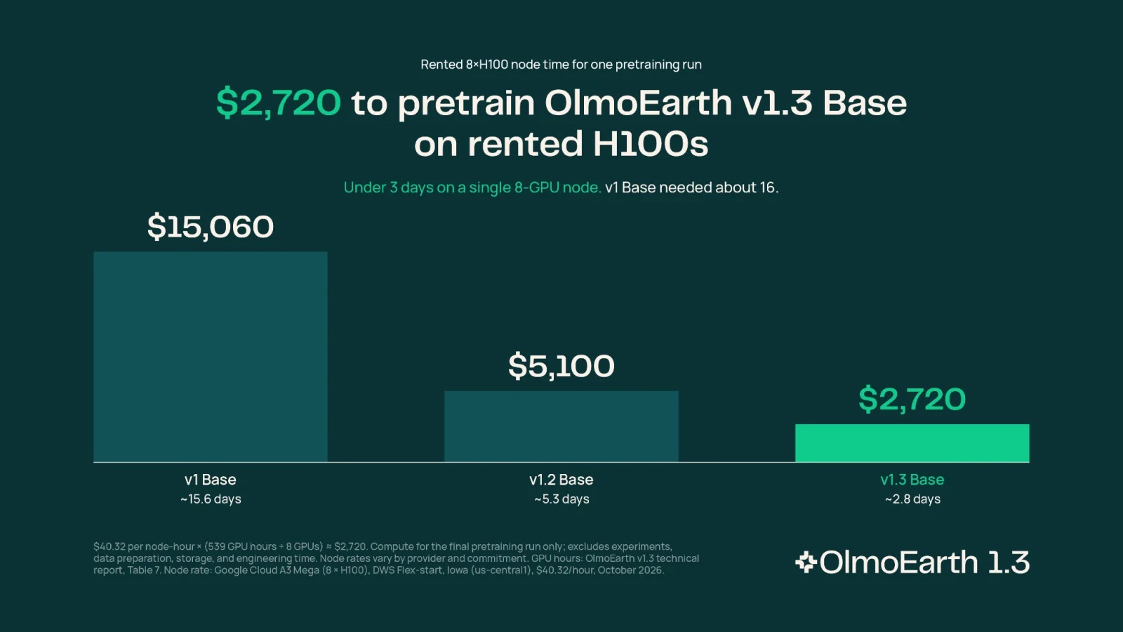 Bar chart of H100 pretraining cost for OlmoEarth v1, v1.2 and v1.3 satellite embedding models
Image: Ai2
Ai2 reports that v1.3 was its cheapest OlmoEarth model to train, taking 53 percent of the computing time of v1.2 and 18 percent of v1, with 50 and 22 percent of the carbon emissions. The chart in the post lists rented H100 pretraining costs of $15,060 for v1 Base, $5,100 for v1.2 Base and $2,720 for v1.3 Base. A reproduction budget under three thousand dollars for the final run is unusual for a global foundation model, and a real point for open science. It excludes experiments and earlier runs, which the post does not price.
A worked example: gold mining in Peru
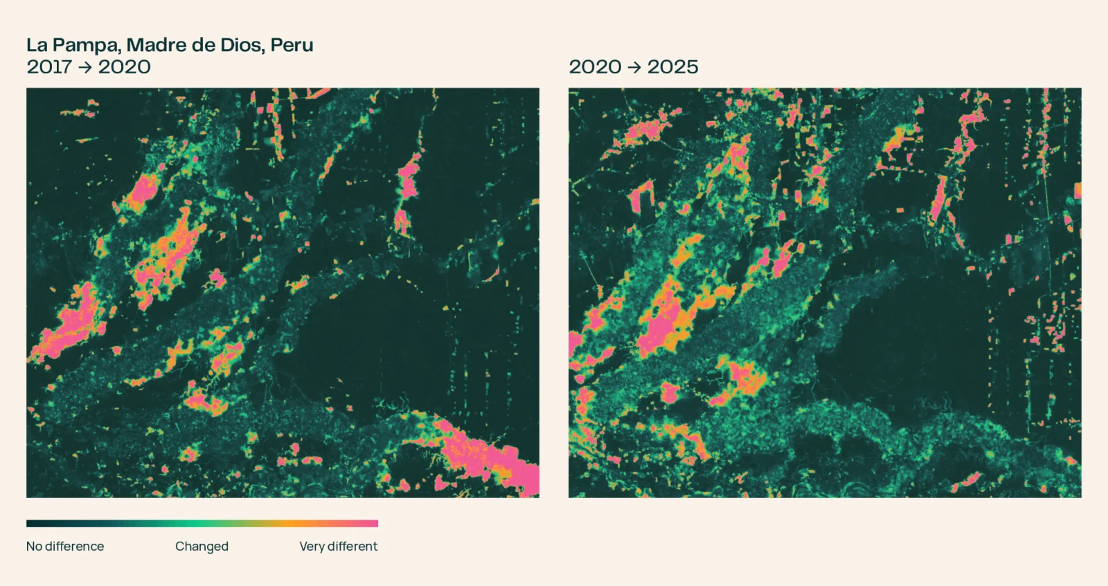 OlmoEarth satellite embeddings change maps of La Pampa, Peru, 2017 to 2020 and 2020 to 2025
Image: Ai2
Ai2's showcase is Madre de Dios, Peru. Illegal gold mining around La Pampa peaked in 2017 and 2018, clearing more than 1,200 hectares of forest in the buffer zone of the Tambopata National Reserve, according to Amazon Conservation's MAAP program, which Ai2 cites. Peru's Operation Mercurio shut most of it down in February 2019. Did it stay down?
Comparing each pixel's embedding across years, with no model training, the 2017 to 2020 pair lights up where mining was spreading southeast. The 2020 to 2025 pair shifts: the crackdown is visible, but the map is not dark, with pockets in the northwest still operating and the old mining zone still changing through regrowth and renewed digging. Ai2 adds that the Associated Press reported in August 2026 that Peru sent navy patrols back into the reserve after prosecutors found mining had crossed into Tambopata. The point is the workflow: a change map from a subtraction, not a training run.
Other uses Ai2 names include smallholder crop classification in Kenya, brick kiln detection west of Dhaka, fire damage in Indonesia and gold mining in the Peruvian Amazon.
Using the Embeddings Explorer
The Explorer renders the embeddings as a false-color planet map. Per Ai2 you can:
- Pan anywhere and flip between years.
- Open the underlying Sentinel-2 imagery to check the map against reality.
- Click a place to find similar places.
- Drop a few labeled points, train a small classifier on the spot, and export the result as a GeoTIFF.
No account or setup is needed. Ai2 contrasts this with a fine-tuning run measured in hours: a first pass takes seconds, and the Explorer can tell you whether a task deserves fine-tuning compute. Each embedding also carries provenance: open tables for each 20 km tile and year list the Sentinel-1, Sentinel-2 and Landsat scenes read, with links to the public catalogs, so you can trace a pixel to its source imagery.
How does this compare with Google's AlphaEarth?
Google DeepMind's AlphaEarth Foundations released embeddings rather than the model, a distinction Ai2 has drawn before. OlmoEarth's pitch is openness of the whole stack, weights, data and code, plus the Explorer. For related work on how Google is wiring geospatial data into agents, see our coverage of Google Earth AI's geospatial reasoning agent. On the Ai2 side, the same lab recently published a 3 km extreme-weather emulator, HiRO-ACE v2 and a fairness stress test for LLM decisions, which shows how wide its output now runs.
Limits and caveats
- Self-reported benchmarks. The 27 evaluations come from Ai2. Independent replication will take time.
- Coverage is uneven. Only 2023 to 2025 are global at launch; earlier years cover select countries.
- License. The OlmoEarth Artifact License is open but not necessarily the same as Apache or MIT. Check terms for commercial and redistribution use.
- Annual resolution. One vector per pixel per year hides within-year events; for specific windows you need Studio and your own compute.
- Interpretation risk. An embedding change shows that something changed, not what. Mining, regrowth and farming can look alike without ground labels.
- Size. About 150 TB per year of embeddings means you will want to pull tiles for your region, not the globe.
What this means for builders
If you work with geospatial data, the cost curve just moved. You can prototype a land-cover or crop classifier on a laptop from a handful of labels, and decide whether to fine-tune afterwards. If you build agents that answer questions about places, open embeddings with provenance give you something to ground them in. And for anyone following AI for science, it is another example of an open lab matching or beating a big-tech release with a much smaller bill, a theme we also see in discoveries like Claude Code finding a planet candidate in NASA TESS data and in Hugging Face's open DNA model.
Getting started
- Open the Embeddings Explorer from Ai2's announcement and look at a region you know.
- Pull 2025 embeddings for that region from Source Cooperative.
- Train a small classifier on your own labels (scikit-learn is enough) and compare 64-d and 128-d.
- Run a year-over-year difference for change detection.
- Move to OlmoEarth Studio only if you need exact dates or other resolutions.
Related reading
- Google Earth AI geospatial reasoning agent
- Ai2 HiRO-ACE v2 extreme weather emulator
- Ai2 FairStress LLM fairness benchmark
- Ai2 GPU cluster scheduler
- Claude Code finds a planet candidate in TESS data
- Hugging Face Carbon DNA model
Figures come from Ai2's October 22, 2026 announcement and are Ai2's own results.